Hurricane Erin exploded in strength and became a major storm in Atlantic waters just north of the Caribbean on Saturday, rapidly powering up from a tropical storm in a single day and bringing heavy rains and high winds to islands in the region.
The first Atlantic hurricane of 2025, Erin reached Category 5 status before weakening somewhat and becoming a Category 4 storm, with maximum sustained winds of 140 mph (220 kph), according to the National Hurricane Center in Miami.
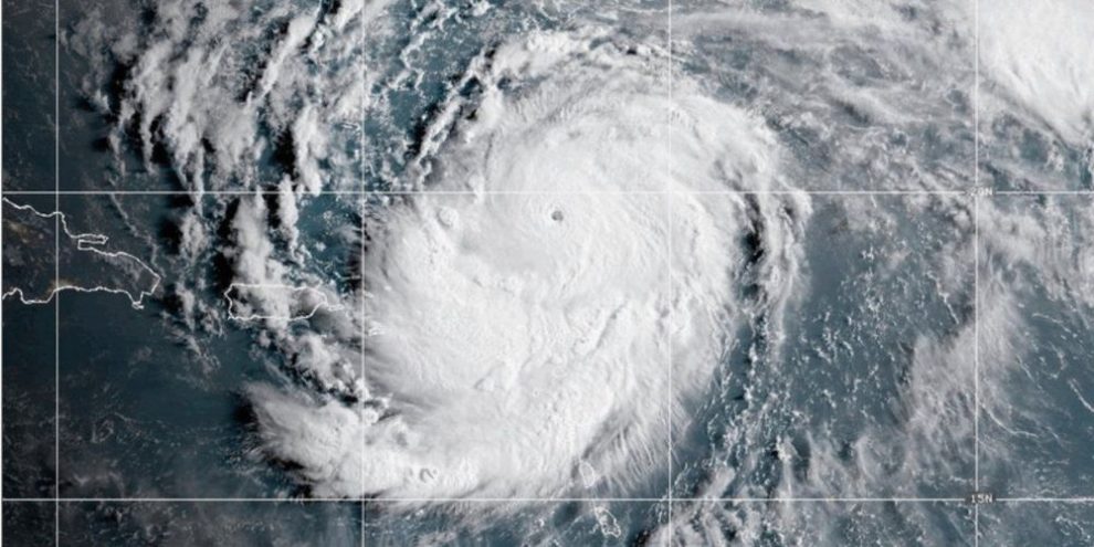
Late Saturday night, the center reported that Erin was “undergoing structural changes” but was still “formidable” as its rain and winds buffeted Puerto Rico and the Virgin Islands.
Barrie's News Delivered To Your Inbox
By submitting this form, you are consenting to receive marketing emails from: Central Ontario Broadcasting, 431 Huronia Rd, Barrie, Ontario, CA, https://www.cobroadcasting.com. You can revoke your consent to receive emails at any time by using the SafeUnsubscribe® link, found at the bottom of every email. Emails are serviced by Constant Contact
The storm’s center was about 145 miles (230 kilometers) north-northeast of San Juan, Puerto Rico, and it was heading toward the west-northwest at 14 mph (22 kph). It was not forecast to make a direct hit on land.
Hurricane center director Mike Brennen said Erin grew into a “very powerful hurricane,” with its winds gaining 60 mph (96 kph) in about nine hours.
Forecasters predicted it will remain a major hurricane into the coming week.
Erin close enough to land to trigger flooding, landslides
The storm's center was forecast pass north of Puerto Rico, according to the National Hurricane Center. Nevertheless, it said, heavy rain in some areas could trigger flash flooding, landslides and mudslides.
Tropical storm watches were issued for St. Martin, St. Barts and the Turks and Caicos Islands.
The National Weather Service in San Juan issued an alert for Saturday night for nearly two thirds of Puerto Rico, warning of 50 mph (80 kph) winds and urging people to shelter in safe structures. Power was knocked out to about 130,000 customers in the territory.
Locals and tourists walked and shopped as usual earlier in the day in Puerto Rico's capital. Restaurants were busy, and despite warnings to avoid beaches, people could be seen in the water.
Sarahí Torres and Joanna Cornejo, who were visiting from California for a Bad Bunny concert, said they decided to go to the beach and wade in because the skies were calm.
“The weather looked fine, so we came out,” Torres said.
The U.S. government deployed more than 200 employees from the Federal Emergency Management Agency and other agencies as a precaution. Puerto Rico Housing Secretary Ciary Pérez Peña said 367 shelters were inspected and ready to open if needed.
Officials in the Bahamas also prepared shelters and urged people to monitor the storm's progress.
Powerful rip currents could affect the U.S. East Coast from Florida to the mid-Atlantic next week, despite the eye of the storm forecast to remain far offshore, Brennan said.
An ‘incredible’ race from tropical storm to Category 5
Hurricane specialist and storm surge expert Michael Lowry said Erin gained strength at a pace that was “incredible for any time of year, let alone Aug. 16.”
Lowry said only four other Category 5 hurricanes have been recorded in the Atlantic on or before Aug. 16.
The most powerful storms tend to form later in the year, with the hurricane season typically peaking in mid-September.
In October 2005, Hurricane Wilma rocketed from a tropical storm to a Category 5 in less than 24 hours, according to National Hurricane Center advisories from that time. Wilma weakened to a Category 3 hurricane before striking Florida. And in October 2007, Hurricane Felix took just over a day to go from a tropical storm to Category 5.
Including Erin, there have been 43 hurricanes that have reached Category 5 status on record in the Atlantic, said Dan Pydynowski, senior meteorologist at AccuWeather, a private forecasting company.
“They’re certainly rare, although this would mark the fourth year in a row that we’ve had one in the Atlantic basin,” Pydynowski said.
Warming climate linked to storms strengthening faster
Scientists have linked rapid intensification of hurricanes in the Atlantic to climate change. Global warming is causing the atmosphere to hold more water vapor and is spiking ocean temperatures, and warmer waters give hurricanes fuel to unleash more rain and strengthen more quickly.
Storms that ramp up so quickly complicate forecasting and make it harder for government agencies to plan for emergencies. Hurricane Erick, a Pacific storm that made landfall June 19 in Oaxaca, Mexico, also strengthened rapidly, doubling in intensity in less than a day.
Erin is the fifth named storm of the Atlantic hurricane season, which runs from June 1 to Nov. 30 and is expected to be unusually busy. Six to 10 hurricanes are predicted for the season, including three to five reaching major status with winds of more than 110 mph (177 kph).