After an unseasonably warm fall, winter has made its presence unmistakably clear across Barrie and much of Central Ontario.
And did so earlier than expected. Winter officially arrived at 10:03 a.m. Sunday.
Climatologist David Phillips says the region’s recent run of cold temperatures and frequent snowfall is the result of several competing climate forces coming together at once, including a strong early-season polar vortex, lake-effect snow, and broader climate trends.
“In Canada, we had the warmest fall on record, and in Ontario, the fourth-warmest on record,” Phillips said. “September and October were on fire - more than two degrees warmer than normal - and then all of a sudden November came, and things cooled right off.”
That abrupt shift caught many off guard. Phillips notes that while people often think of winter as December through February, November plays a critical role in setting the stage — and this year, it delivered.
Since late November, the region has seen almost uninterrupted snowfall. “In the last three weeks, we’ve had only snow - it snowed on every day,” Phillips said. “Out of 21 days, there were flakes falling on 20 of them.”
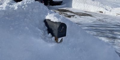
By mid-December, Barrie had already received roughly 100 centimetres of snow — about 45 per cent more than what’s typical for that point in the season. While not record-breaking, Phillips says the key difference has been the cold.
“The snow has lasted,” he explained. “We haven’t had melting temperatures or rain, so it’s just stayed there. Every time you look out the window, you see what’s accumulated over the last few weeks.”
Much of that snowfall has been driven by lake-effect systems, fuelled by unusually warm lake waters. “It was just like a hot tub out there,” Phillips said, referring to Georgian Bay and surrounding lakes. When cold air moves in under the right wind conditions, it can trigger intense - and highly localized - snowfalls.
- Listen below to our full interview with David Phillips, it's the first item.
Looking ahead, Phillips expects winter to remain unpredictable. While a brief warm-up with rain is possible around the holidays, he doesn’t foresee a snow-free Christmas. “All you really need is two centimetres of snow on the ground,” he said. “And we have far more than that.”
As for the rest of the season, confidence is lower than usual. La Niña, climate change, warm ocean temperatures and the ever-present polar vortex are all pulling in different directions.
“So who’s going to win?” Phillips asked. “That’s the problem.”
His best guess: the toughest stretch may already be behind us. “We’ve had a hard beginning,” he said, “but it should get less tough as we move on.”
That’s welcome news for winter-weary residents - though for skiers, snowmobilers and local recreation businesses, Phillips says the early snowfall has been nothing short of “fantastic.”