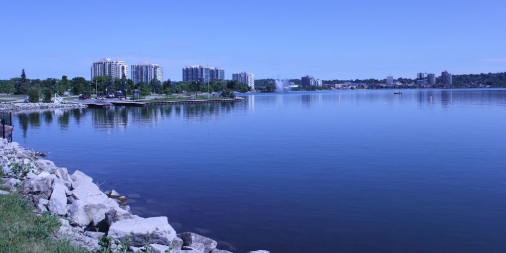
Lake Simcoe, the big lake north of Toronto, is Barrie's backyard. It's where the city cools off in July, where the ice huts pop up every winter and, less glamorously, where a good chunk of the region's tap water comes from.
Here's everything worth knowing about our home lake, from how big it really is to when the perch are biting.
Quick facts: Lake Simcoe at a glance
- Fourth-largest lake entirely within Ontario
- About 65 kilometres north of Toronto
- Surface area: 722 square kilometres
- Shoreline: 240 kilometres
- Average depth: 15 metres. Deepest point: 42 metres, near the mouth of Kempenfelt Bay
- Watershed: about 3,400 square kilometres across 20 municipalities
- Drinking water source for seven municipalities
- Named in 1793 after the father of John Graves Simcoe, Upper Canada's first lieutenant-governor
Stay up to date with what's happening around Lake Simcoe
By submitting this form, you are consenting to receive marketing emails from: Central Ontario Broadcasting, 431 Huronia Rd, Barrie, Ontario, CA, https://www.cobroadcasting.com. You can revoke your consent to receive emails at any time by using the SafeUnsubscribe® link, found at the bottom of every email. Emails are serviced by Constant Contact
How Big Is Lake Simcoe?
The Lake Simcoe Region Conservation Authority (LSRCA) puts the surface at 722 square kilometres, with 240 kilometres of shoreline. The lake averages 15 metres deep and drops to 42 metres at its deepest point, near the mouth of Kempenfelt Bay, the long arm that reaches west into Barrie.
The lake sits at the centre of a watershed roughly five times its size, about 3,400 square kilometres of land. Eighteen major river systems feed it, along with 4,225 kilometres of smaller creeks and streams. Water leaves the lake at the north end, flowing through Lake Couchiching and the Severn River to Georgian Bay. Lake Simcoe is not one of the Great Lakes, but it is part of the Trent-Severn Waterway, and Parks Canada manages its water levels.
History of Lake Simcoe
The lake has had three names. The Huron called it Ouentironk, which the LSRCA translates as "beautiful water." Early European settlers called it Lake Toronto. In 1793, John Graves Simcoe, the first lieutenant-governor of Upper Canada, renamed it after his father.
Lake Simcoe Facts
A few more facts worth knowing:
- The watershed holds 75 fish species, more than 50 of them in the lake itself.
- More than 32 species at risk live in the watershed.
- Recreation on the lake brings in more than $200 million a year, and about 80 per cent of that is tied to ice fishing.
- The first invasive species, common carp, arrived in 1896 when a Newmarket pond overflowed.
- Farmland covers 36 per cent of the watershed. Forests and wetlands cover 13 per cent each. Urban land is 8 per cent.
- The biggest island, Georgina Island, is home to the Chippewas of Georgina Island First Nation, whose reserve also takes in Snake and Fox islands. Thorah Island, on the east side, is cottage country.
Lake Simcoe Beaches
Public beaches ring the lake, from Barrie's waterfront to Georgina's string of small parks on the south shore, plus three provincial parks. Most are sandy and all get busy on summer weekends. Go early, pack a cooler and, if you're headed to a Barrie beach, leave the tent at home (more on that below).
RELATED: See which beaches are open and which are not safe to swim in today ...
Barrie
- Centennial Beach (65 Lakeshore Drive). The big one: a large sandy beach with a playground, beach volleyball and basketball courts, picnic tables, washrooms, parking, a boat launch and the Splash On water park. Supervised seven days a week from the end of June to mid-August. Restaurants are within walking distance.
- Johnson's Beach (2 Johnson Street, next to the Barrie Yacht Club). Smaller, with washrooms, change rooms and parking. Supervised seasonally.
- Minet's Point Beach (10 Lismer Boulevard). Unsupervised, with a playground, picnic tables, washrooms and a launch area for non-motorized boats.
One rule for all three: no tents or sunshades. Single-pole umbrellas are fine.
Innisfil
Innisfil Beach Park (676 Innisfil Beach Road) is the one with everything. It's 27.6 hectares on the lake with several beach areas, a boat launch, a snack bar, washrooms, a playground, a BMX pump track and an off-leash dog area with water access at the park's east point. Dogs are not allowed on the beaches themselves. Parking is free for Innisfil residents with a pass; everyone else pays, and the gate closes to visitors when the lots fill up. The park also lends a floating beach wheelchair, booked at least 24 hours ahead.
Georgina and the south shore
Georgina runs a string of small waterfront parks along Cook's Bay and the south shore. None have lifeguards and none allow dogs on the sand, but there are a lot of them. The ones with the most going on:
- Bonnie Park (1 Bonnie Boulevard, Jackson's Point). Playground, picnic shelter and washrooms in season.
- Claredon Beach Park (9 Windy Shore Drive, Keswick). On Cook's Bay, with a playground and picnic table.
- De La Salle Park (1940 Metro Road, Jackson's Point). Beach volleyball, outdoor showers, washrooms in season and an accessible beach mat and beach wheelchair. Visitor parking lot.
- Holmes Point Park (131 Holmes Point Road, Pefferlaw). Playground and picnic tables. Visitor parking lot.
- North Gwillimbury Park (775 Lake Drive North, Roches Point). On Cook's Bay, with a picnic shelter and playground.
- Willow Beach Park (1506 Metro Road, Willow Beach). Playground, drinking water and washrooms in season. Visitor parking lot.
Visitors can park in the De La Salle, Willow Beach and Holmes Point lots. The other lots are first-come, first-served, with pay-and-display for anyone without a resident pass. They close when full.
Provincial parks
- Mara Provincial Park (about 10 minutes south of Orillia). A quieter beach with 105 campsites, showers, a playground and a lifejacket lending program. Open May to late September.
- McRae Point Provincial Park (Ramara Township, near Orillia). Swimming, a dog beach, 203 campsites with 125 pull-throughs built for big rigs, a small-boat launch, three docks and a 1.2-kilometre nature trail. Open May to mid-October.
- Sibbald Point Provincial Park (Sutton West, on the south shore). A large sandy beach, 583 campsites, a boat launch, two dog beaches and Eildon Hall, the Sibbald family museum, open in July and August. Camping runs May to late October; day use is open year-round.
Lake Simcoe Fishing
Lake Simcoe sits in Fisheries Management Zone 16, but it has its own rules on top of the zone's. The lake-specific ones matter most for the cold-water fish.
Seasons and limits
- Lake trout and lake whitefish: open January 1 to March 15 and from the second Saturday in May to September 30. Sport licence limit is two per day for each.
- Lake herring (cisco): same season as lake trout. Limit two.
- Yellow perch: open all year. Limit 50 per day, with a possession limit of 100.
- Walleye: January 1 to March 15 and the second Saturday in May to December 31. Limit four, only one over 46 centimetres.
- Northern pike: January 1 to March 31 and the second Saturday in May to December 31. Limit six.
- Bass: fourth Saturday in June to November 30. Limit six.
- Muskellunge: closed all year on Lake Simcoe.
Those are sport licence limits. Conservation licence limits are lower, and the province updates the regulations summary every year, so check the current Zone 16 page before you go.
Ice fishing
Come January, the lake turns into a small town of huts. Ice fishing is the lake's biggest draw, and the LSRCA ties about 80 per cent of the lake's recreation dollars to it. A few rules:
- Ice huts in Zone 16 must be off the ice by March 15. That's a safety deadline ahead of the thaw, not the end of the season.
- A hut made of anything other than fabric, or a fabric tent of 7 square metres or more, must be registered with Ontario. Registration is free and the number has to be displayed on the outside of the hut in characters at least 6.3 centimetres tall.
Lake Simcoe Ice Safety
Ice is never the same thickness everywhere on a lake this size, so check as you go. The Canadian Red Cross says ice should be at least 15 centimetres thick for walking or skating and 20 centimetres for a group. For snowmobiles and ATVs, the Red Cross says 25 centimetres; Ontario's own guidance is 20 centimetres of clear blue ice for a snowmobile and 30 centimetres or more for a light vehicle. Go with the more cautious number: 25 centimetres before you take a sled out, 30 before a car.
Colour tells you a lot. Clear blue ice is the strongest. White or opaque ice is much weaker, and Ontario says to double the thickness requirement for it. Grey ice is unsafe, and honeycombed ice, which shows up during thaws and in spring, should be avoided altogether.
Whether you're on the sand in July or on the ice in January, the lake is the best thing about living here. Treat it well. Seven municipalities drink from it.
Frequently Asked Questions
722 square kilometres of surface, 240 kilometres of shoreline, 15 metres deep on average and 42 metres at its deepest point near Kempenfelt Bay.
Yes. Barrie, Innisfil and three provincial parks run public beaches on the lake. Georgina alone runs about ten waterfront parks with swimming; the six best-equipped are listed above. Advisories are posted at the beaches.
More than 50 species, including lake trout, lake whitefish, yellow perch, walleye, northern pike and bass.
March 15, the removal deadline for Fisheries Management Zone 16.
North of Toronto, between Simcoe County, York Region and Durham Region. Barrie is on its western arm, Kempenfelt Bay; Georgina is along the south shore; Orillia is at the north end.
John Graves Simcoe, Upper Canada's first lieutenant-governor, renamed it in 1793 in honour of his father. Before that it was Lake Toronto to settlers and Ouentironk to the Huron.